Uma breve revisão sobre metodologias para a reconstrução 3D de ambientes urbanos pelo uso de nuvem de pontos
Rodolfo G. Lotte, and Cláudia M. de Almeida
Download paper
Download poster
Abstract
Urban environments are densely populated areas composed mostly by residential, commercial and industrial sectors and alike. From airborne or satellite images shows off cleared linear patterns due to predominance of artificial structures, such as roads, buildings and impervious surfaces. Currently, 54% of the world population lives in urban areas and it is estimated that by 2050 there will be an increasing to 66% of the population, which makes monitoring and management of urban environments one of the most important challenges of the twenty-first century. The systematic collection of information about cities structures are extremely important for the management of those environments. The precise mapping expresses the idea of organization and possibility of future planning, since the disposal of urban objects, their state of preservation and geometry contribute, for instance, in monitoring, drawing up plans for greater comfort of the population, even so, enables computational simulations of numerous natural disasters and their potential impacts. Two major data sources have been an efficient alternative to survey information about the geometry, laser sensors, called LiDAR (Light Detection And Ranging) and optical, that is combined with techniquies of photogrammetry by stereo-pair. Both have become the focus of studies involving 3D reconstruction of urban features in the last decades, in particular, volumetric
information. The challenge in extracting volumetry of urban environments resides in its heterogeneity. Among the methods proposed over the years, many of them have adopted the workflow: detection and reconstruction, which first the buildings edges are delineated and subsequently geometric modeling procedures are applied to reconstruct the 3D building representation. In this study, we briefly present the most widely used methods for 3D reconstruction, separated in methods for the detection and reconstruction.
Info! Dear researcher/scientist/academic, you may find some Wikipedia references in this page, which are totally directed for those that might not be familiar with terms and need a more illustrative and didatical understanding. Please, fell free to contribute at any moment.
Contextualization
Presentation
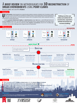 This work has been presented in a poster form (left), during the National Remote Sensing Symposium (SBSR), hosted by the National Institute for Space Research (INPE), in Santos, 2017. The poster can be download in the green buttom at the top of this page.
Cite this paper
@InProceedings{lotte2017b,
  Title                    = {Uma breve revisão sobre metodologias para a reconstrução 3D de ambientes urbanos pelo uso
  de nuvem de pontos},
  Author                   = {Rodolfo G. Lotte and Cl\'audia M. Almeida},
  Booktitle                = {Anais XVIII Simp\'osio Brasileiro de Sensoriamento Remoto - SBSR},
  Year                     = {2017},
  Address                  = {Santos},
  Month                    = {Abril},
  Number                   = {2017},
  Volume                   = {18},
  Organization             = {Instituto Nacional de Pesquisas Espaciais (INPE)},
  Pages                    = {3377-3384},
  Publisher                = {SBSR São José dos Campos},
  url                      = {http://urlib.net/8JMKD3MGP6W34M/3PSLSQU}
}