Experiences

Deloitte Touche Tohmatsu
AI & Data Lead - ( Jul. 2023 - present date )
São Paulo, SP, Brazil
Full-time
Data science, research and management of activities involving data, analysis, and validation. Tasks involve the elaboration of methodologies using MLOps workflow to deal with multiple applications sensitive to data. The range of possibilities is wide when the products involve the analysis of data, it counts basically every statistic tools, as well as Machine Learning, aligned with the facilities of Cloud Computing.
Deloitte is one of the largest professional services firms in the world, providing a wide range of services in auditing, tax, consulting, and advisory. The company was founded in 1845 by William Welch Deloitte in London and has since grown into a global network of member firms operating in more than 150 countries. Deloitte serves clients across various industries, including finance, technology, healthcare, consumer products, energy, and more. Deloitte is known for its commitment to innovation and thought leadership. The company frequently publishes research reports and insights on various business-related topics and emerging trends (Read More).
Projects:
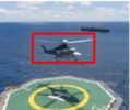 Air traffic monitoring over oil platforms: Monitoring helicopter landings and departures over offshore oil platforms is crucial for ensuring operational safety and compliance with regulations. Using an AWS-based infrastructure, hundreds of videos from multiple platforms can be processed continuously, enabling real-time analysis and reporting. This project employs multiple Deep Learning models to extract key safety metrics during landing and departure operations, such as counting the number of passengers, assessing landing quality, analyzing helicopter position, and verifying adherence to safety inspections. The scalable and automated nature of this system enhances oversight, minimizes human error, and supports proactive decision-making to maintain high safety standards in these critical operations.
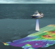 Intelligent bathymetric mapping of oceans: Bathymetry mapping around oil platforms is vital for ensuring operational safety and protecting natural and human-made targets. Using acoustic imaging, high-resolution sonar data can reveal underwater features like hazards and infrastructure. Machine learning algorithms further enhance efficiency by automating the processing and analysis of these images, enabling accurate and rapid identification of critical targets while supporting environmentally responsible operations.
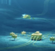 Well Drilling Engineering: It is a specialized branch of engineering that deals with the design, planning, and execution of drilling operations to extract oil, gas, water, or other resources from the subsurface of the Earth. It involves various technical and logistical aspects to create boreholes or wells that reach the target reservoirs safely and efficiently. In this sense, this project tends to support activities on data analysis and future predictions. Activities involving solution construction, data organization, continuous ML flows, developments, database and task managements.
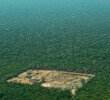
 Vegetation Loss Monitoring: Google Earth Engine (GEE) serves as a powerful tool for monitoring vegetation loss, offering a cloud-based platform that enables the analysis of amounts of geospatial data efficiency. Leveraging sources like MapBiomas, Global Forest Watch (GFW), and PRODES/INPE, researchers and decision-makers gain access to comprehensive datasets that track land cover changes, deforestation, and other critical environmental metrics. The integration of these resources within GEE in this project, was a great effort to have a perspective of the deforestation in time-series, which empowered the insights over the region of interest.

Bioverse Labs
Machine Learning and Remote Sensing Lead - ( Jul. 2020 - May. 2024 )
São Paulo, SP, Brazil
Part-time
Development, research and management of activities involving remote sensing geoprocessing and facilities to the land-use aerial monitoring. Tasks involve the elaboration of methodologies to deal with very high resolution images for multiple purposes, such as the public security, monitoring, inspection and assistance to federal institutions to combat deforestation, among others.
Bioverse Labs has created species monitoring solutions under the PRECISION BIODYNAMICS TM system, that consist of a AI-powered technologies enabling farmers and governments to monitor species population dynamics in real time. Through the integration of smart low-cost IoT sensors, mobile application (BIOMAP TM ) and proprietary machine learning algorithms designed to detect both pest and beneficial species. Applications for our PRECISION BIODYNAMICS TM solutions include monitoring insect populations in conventional and organic open field and greenhouse agriculture, monitoring invasive forest pests, and monitoring urban ecosystems to detect threats to human health (Read More).
Projects:
 Autonomous tree species mapping: Through the use of very high resolution images, automatically identify specific tree species. The detection technique will be composed by a set of image processing operators, mainly by Machine Learning techniques, which will allow to explore the spectral, spatial and contextual properties of this species in a broad and emerging way. In addition, it is expected that the methodology has reasonable robustness and accuracy, therefore, the methodology will be composed of scalable, interoperable, flexible and easily accessible architectures, allowing for any future modifications, experiments or replications.
 XPRIZE Rainforest: Every single day we’re working to create a better world, a world of infinite possibilities. A more hopeful future for all. A world where everyone’s days are spent imagining, creating, and collaborating, not fearing and fighting. A world where everyone has access to clean water, nutritious food, affordable housing, effective learning, top-tier medical care and non-polluting, abundant energy. Create a better future for all. Lend a hand, share an idea, become an active voice in our community or donate - each one of us has the power to make a difference (Read More).
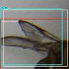 Autonomous insect mapping: Through the use of very high resolution images, automatically identify specific insects species. The detection technique will be composed by a set of image processing operators, mainly by Machine Learning techniques. In addition, it is expected that the methodology has reasonable robustness and accuracy, therefore, the methodology will be composed of scalable, interoperable, flexible and easily accessible architectures, allowing for any future modifications, experiments or replications.

Santiago & Cintra Consultoria (SCCON)
Computer Vision and Remote Sensing specialist - ( Dez. 2020 - May 2023 )
São Paulo, SP, Brazil
Full-time
Development, research and management of activities involving remote sensing geoprocessing and facilities to the land-use aerial monitoring. Tasks involve the elaboration of methodologies to deal with very high resolution images for multiple purposes, such as the public security, monitoring, inspection and assistance to federal institutions to combat deforestation, among others.
The use of images of very high spatial and temporal resolution, has become a trend due to the fact that its viability today is more feasible. For example, the availability of storage resources, cloud computing, technologies for handling large amounts of data, among others, are examples of components that support applications involving large amounts of data and, in addition, with high resolution and availability (Read More).
Projects:
 Dedicated support: Support dedicated to the Brazilian Federal Police (PF), which is part of the inspection program and the initiation of operations through orbital images of very high resolution. The tasks carried out in this area mainly involve the development of tools for monitoring Brazilian forests in order to preserve them and break the chain of illegal land use, as well as other operations of an environmental nature.
 Autonomous image enhancement: Right after the acquisition and selection of images, some attenuation or noise can result in visually bad images, with contrasts that are inadequate for basic interpretation. Therefore, due to the large amount of daily images, it is necessary to routines that automatically correct characteristics that can hinder the interpretation of the image, highlighting strategic targets in order to provide better conditions for analysis and interpretation.

Amazon Deforestation Monitoring (PRODES)
Scentific Development and Remote Sensing - ( Jan. 2020 - Dec. 2020 )
National Institute for Space Research (INPE), São José dos Campos, SP, Brazil
Full-time
Development, research and management of activities involving remote sensing geoprocessing and facilities to the land-use aerial monitoring, especicaly, at the brazilian Amazon.
The PRODES project performs satellite monitoring of recent deforestation in the Legal Amazon and produces, since 1988, annual deforestation rates in the region, which are used by the Brazilian government to establish public policies. The annual rates are estimated based on the deforestation increments identified in each satellite image that covers the Legal Amazon. The first presentation of the data is made for December of each year, in the form of an estimate. The consolidated data are presented in the first half of the following year (Read More).
Scentific Development - autonomous deforestation monitoring
CNpQ - National Institute for Space Research (INPE)
A multidisciplinary job, with tasks surrounding the analysis, processing and investigation of methodologies to improve the estimatives of deforestation rates over brazilian Amazon. The technologies set is wide, mostly use of scientific tools, such as R and Python, but not restrict to that. Research tasks are also encouraged.
Projects:
 Autonomous monitoring: Beyond the tasks under the monitoring of deforestation through aerial images, one of the promising line of development, is to mitigate ways to automate the whole process, or part of it. In this case, we would have faster and accurate answers to those questions involving the forest losses. This work focuses mainly on image classification methodologies (specially the ones regarding Deep Learning architectures) with the objective of obtaining fast and, at the same time, consistent results.
 Cloud Programming: With the emergence of new technologies in the computational scope, both instrumental (processing power, storage and occupation) as well as the emergence of frameworks and algorithms, a new area of studies has been formed within the project. To keep up with technological trends, the entire infrastructure and dynamism of the project is gradually being modernized. One of these changes is the partial processing of the classification of images in the Cloud. In this work, scripts are being developed to be deployed on Amazon AWS infrastructure, together with repositories already publicly available, such as Landsat-8, Sentinel-1 and 2 collections, CBERS-4B, among others.

Geopixel Geotechnologies and IT Solutions
Technical Lead in Remote Sensing - ( Jun. 2019 - Dec. 2019 )
Technologic Park, São José dos Campos, SP, Brazil
Full-time
Assistance, research and management of activities involving remote sensing geoprocessing and facilities to the land-use aerial monitoring.
More under a commertial environment, the practices here comprises not only the difficulties in Remote Sensing and Geoprocessing, but also the ability to perceive inconsistencies, risks, errors, which methodologies the team could be more benifited (by computational costs and time). Once identified, lines of solutions are delineated, and finally reaching the best workflow based on a certain scenario.
Projects:
 ITCG, Paraná: This was a mapping project, executed by a team of 10 members, all geoprocessing analysts, where the whole state of Paraná (approximately 199,315 km^2), Brazil, was mapped in 13 classes of land use and coverage. Personally, my tasks in this project involves project management, guiding and support on GIS and Remote Sensing operations. The basic mapping process was consisted by manual mapping, evaluation, correction, evaluation and delivering. Due to the sequence of production, the procedure were treated as such, which brought more flexibility to work with the team.
 COPENER, Bahia: This was a mapping project, executed by a team of 8 members, all geoprocessing analysts, where 22 classes were mapped. Personally, my tasks in this project involves project management, guiding and support on GIS and Remote Sensing operations.
 L’Oreal, Piauí: This was a mapping project, executed by a team of 10 members, all geoprocessing analysts, where 13 classes were mapped, but the interest was to map forests of Carnaúba, a special tree responsible to produce a particular ingredient, the Carnaúba wax. Personally, my tasks in this project involves project management, guiding and support on GIS and Remote Sensing operations.

Study and Brazilian Monitoring of Space Weather (EMBRACE)
National Institute for Space Research (INPE), São José dos Campos, SP, Brazil
Full-time
Development and technologies activities regarding the Space Weather monitoring
As System Analyst/Developer during a long period at the EMBRACE/INPE, I could learn a bit more about technologies and practices involving the professional development of big projects. Always surrounded by experient people, the EMBRACE/INPE has broght important skills that allowed me to be more prepared over a complex and dynamic field. Besides, the department also provided a wide variability of scientific topics on Astrophysics, such as Solar, Interplanetary Medium, and Earth activities, and the strategies regarding its monitoring. To go a bit through the applications that I got involved, I listed and explained below each of them.
System Analyst - ( Abr. 2018 - Jun. 2019 )
Datainfo Soluções Tecnologia Ltda
Solutions mostly in Python, maintainance of old applications in Java full-stack layout in MVC, using technologies to receive raw data, store it in databases (PostgreSQL), queue files to be processed on demand and in line (RabbitMQ), share the results of processing via JSF, Primefaces, JPA, Highcharts, etc. The new technologies using Django framework, and models calculation by the most used Python libraries, such as scimage-kit, numpy, scilearn, pandas, xarray, so on.
Projects:
 Total Electron Content, TEC: Brazilian space weather application which aims the estimative of ionosphere density throw GNSSs signals. Improvements has been made in the current TEC application available in (Read More). This current development is an extension of the same TEC already published, with an series of fixed issues and better estimates. Before, a couple of orbital instruments were considered to the calculus of ionosphere density estimates. In this release, not only GPS, but also the GLONASS and Galileo were took in account, also the use of DCB files, which gives the exact contribution of each PRN. This made the error (bias) estimative a bit more flexible and clean.
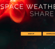 Space Weather Data SHARE, SWDataShare: EMBRACE/INPE holds a set of essencial datasets (raw data), which integrate most of the Space Weather Monitoring environment, such as magnetosphere, ionosphere, solar surface, and interplanetary medium. These huge set of data, is shared through the SWDataShare, where a beautiful and easy to use webpage provide the right tool for downloading raw data to do your own researches, the tool go since UI components, until APIs (Read More).
 Interplenatary Medium, Solar Wind (Final): After the direct observation of the sun, monitoring the physical parameters of the solar plasma on the Lagrangian Point L1 is the best experimental tool to understand and estimate the possible effects that changes in the space weather condition can cause on natural terrestrial phenomena (such as geomagnetic storms and auroras), on technological systems and on living beings. In order to summarize and standardize the description of the temporal variations of these parameters... (Read More).
System Analyst - ( Apr. 2015 - Jul. 2017 )
Indra Company
Solutions mostly in Java, full-stack resolution in MVC development, using technologies to receive raw data, store it in databases (PostgreSQL), queue files to be processed on demand and in line (RabbitMQ), share the results of any processing via JSF, Primefaces, JPA, Highcharts, etc.
Projects:
Interplenatary Medium, Solar Wind: After the direct observation of the sun, monitoring the physical parameters of the solar plasma on the Lagrangian Point L1 is the best experimental tool to understand and estimate the possible effects that changes in the space weather condition can cause on natural terrestrial phenomena (such as geomagnetic storms and auroras), on technological systems and on living beings. In order to summarize and standardize the description of the temporal variations of these parameters, we created (initially) four indices to describe the space weather conditions in the interplanetary medium close to the Earth taking into account the solar wind speed and magnetic configuration and its effects on the magnetopause (Read More).
Improved Total Eletronic Content, TEC-II: The TEC-II application, developed together with other institutes researchers, the TEC-II is a refactored version of TEC-I, presented in 2011. In this version, the application was contemplated with a new structure, plus, a new and smarter way to estimate TEC and GNSS receiver bias. However, the new release was just provided locally (as a desktop application), for tests and experiments.
 Total Solar Irradiance, TSI: Total Solar Irradiance (TSI) is the radiation generated by the sun at different wavelengths and received at Earth (1UA). This radiation affects the Earth's climate at different timescales. Accurate values of solar irradiance are important in climate and atmosphere models. Total Solar Irradiance (TSI) was considered constant for a long time, with a value of approximately 1,361 W/m². However, observations revealed variations at different time scales. These observations are restricted to the last solar cycles and are subject to great uncertainties (Read More).
 User Space Weather Workshop, Portal: In order to attempt the demand of Brazilian society, the EMBRACE/INPE Program was created in 2007 with the mission of monitoring, modeling and dissemination of the Space Weather information with investigation of the phenomena and prediction of significant effects in the near space and on the surface of the territory, including impacts on space and terrestrial technological systems. In order to fulfill this mission, the EMBRACE Program collects data and maintains the observation system... (Read More).
 Space Weather Monitor: The EMBRACE/INPE holds a set of essencial datasets (raw data), which integrate most of the Space Weather Monitoring environment, such as magnetosphere, ionosphere, solar surface, and interplanetary medium. In order to download space weather raw data, the user only need to sign up, fill a small form with your university, name and email, then, is able to download as much as their research needs (Read More).
 All-Sky Imager: The All-Sky Imager is an optical device composed by fisheye lens with a field of view of 180°, a system of filters and lenses and a high-resolution CCD camera (1024 x 1024 pixels). The instrument is designed observe the night airglow emissions from the mesosphere (80-100 km altitude) and the ionosphere (200-500 km altitude) regions, in particular the Hydroxyl (OH 700 -900 nm) and atomic Oxygen (HI 630 nm) (Read More).
 EMBRACE Mobile: In order to reach an even larger audience, and to meet the need to view monitoring information on mobile devices, the main products within EMBRACE, such as GOES (X-Ray flux), Magnetosphere monitoring, and Alerts, were assembled so that users could keep track of the latest alerts and status of certain physical media in time real. The application is free to download on Google Play.
System Analyst - ( Jan. 2011 - Dec. 2012 )
CTIS Tecnlogia S.A.
Solutions mostly in Java, full-stack resolution in MVC development, using technologies to receive raw data, store it in databases (PostgreSQL), queue files to be processed on demand and in line (RabbitMQ), share the results of any processing via JSF, Primefaces, JPA, Highcharts, etc.
Projects:
Total Electron Content, TEC-I: The Total Electronic Content (TEC) corresponds to the ionospheric electronic density integrated along the path between the receiver on the ground and the GNSS satellite (Global Navigation Satellite System). TEC's measure unit is TECU (1,016/m^2$). Ionospheric disturbances are proportional to the TEC, being an important parameter in the inference of the positioning error (error of a few meters) and the speed of movement of the receivers (for example, installed in automobiles and airplanes), then errors caused by atmosphere, density and the water vapor (errors of the order of centimeters), also influence the... (Read More).
 Ionosphere: The Ionossonde is a type of radar with peak power of the order of 10kW and average power around 500W, which emits pulses of electromagnetic energy at frequencies varying between 0.5 and 30 MHz, which are transmitted vertically to the layer ionospheric. The digestible serves to provide data for the analysis of the electron density behavior of the ionosphere layers E and F. This equipment uses one transmitter antenna and four receivers. After reception, the signals are recorded and processed, showing... (Read More).
 Scintilation: Ionospheric scintillation in radio wave signals occurs due to the presence of plasma or bubble irregularities in the ionosphere. The bubbles are generated at the magnetic equator after sunset due to plasma instabilities. They tend to move up and map along magnetic field lines along off-equatorial latitudes. Ionospheric scintillation is a rapid variation of amplitude and phase of radio wave signals and occurs when these signals traverse the irregularities of the ionosphere. In practical terms, this... (Read More).
 Magnetosphere: Magnetometers are instruments used to measure the intensity and direction of the Earth's magnetic field. Other uses include mineral prospecting, non-destructive testing of materials, assessment of radio-communication link interference, and satellite attitude control. The INPE Space Weather program uses in its measurements of geomagnetic field variations on the Earth's surface fluxgate magnetometer. In these magnetometers, a nucleus... (Read More).
 High solar frequency, Callisto: It consists of a receiver with dual frequency channel-agile based on consumer electronic products available in the market. Its main features are: low hardware price, software, short assembly time, and both two or more orders of magnitude below already existing spectrometers. The instrument is sensitive to the physical limit and extremely stable. The total bandwidth is 825 MHz, and the width of the individual channels is 300 kHz. A total of 1000 measurements can be made per second. The spectrometer is well suited for low frequency solar radio relevant for research on the... (Read More).

TOols for Open Multi-risk assessment using Observation data (TOLOMEO)
Europian Comission (CORDIS)
Full-time
The TOoLs for Open Multi-risk assessment using Earth Observation data (TOLOMEO) project aimed at, and was able to, developing free/open source tools in the framework of collaborative environment with emphasis on remote sensing analysis tools for risk assessment. The developed software tools have been tested and proved to be robust, easy to use and free. They can thus be used in a collaborative way by researchers and other actors in the Earth Observation (EO) community for extracting information from imagery, and help mapping risk as well as vulnerability and exposure.
Affiliate Research in Remote Sensing ( Jul. 2013 - Jan. 2014 )
University of Pavia - Telecommunication and Remote Sensing Laboratory (TLCLab) - Università degli studi di Pavia, Pavia, Italy
Development of road extractor operators over SAR images, using C++ language and image processing.
Projects:
 BREC Road Extractor Operator: Development of roads network extractor in radar images, using C++ language within InterIMAGE plataform (PUC/Rio). Enables extraction of road network in urban and non-urban areas through the use of high-resolution Synthetic Aperture Radar (SAR) images. The contributions made in this task involves others colleagues
 BREC Road Cross Detection: Development filters of polygons to detect intesection or cross paths of roads, using C++ language within InterIMAGE plataform (PUC/Rio). Allows extracting road junctions based on their type. Both operators description can be found here.
Affiliate Research in Remote Sensing ( Jan. 2013 - Jul. 2013 )
University of Hannover - Institute für Photogrammetrie und Geoinformation (IPI) - Leibniz Universität Hannover, Hannover, Germany
Full-time
By the use of image processing techinique, try to extract and improve road network under noisy scenarios.
Projects:
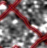
 Network Snakes: This sophisticated image processing technique provides a smart way to improve road networks in high resolution images. The images used, however, is the main challenge in this study. The Snakes technique is most applied under "non-noisy" scenarios. SAR images, used in this work, provide imaging uder areas not imaged by common sensors, with the add of speckle noisy. In this sense, this work comprises ways of to use Snakes under radar images to extract road networks.
It is also recommended to read my consultancies, which include part of my experiences.